Section #9 with Lisa Rose
August 9th, 2020 at 8:45am
Little Manzanita to Reitan Road shore access, 1.25 hours

This is Lisa, otherwise known as 'Fearless' by our group of New Moon Sistahs! This name was given to her several years ago when we all randomly chose temporary tattoos with silly names to embody our individual characters, which sealed the deal for us Sistahs of the New Moon! Maybe this is why I chose her to accompany me on my next section of SUP circumnavigation to paddle under the Agate Pass Bridge?!

Lisa, being a fearless leader, decided to also purchase a Body Glove SUP this summer, and learn to paddle on top of the water! Our paddle began early on a Sunday morning on the northwest side of the Island, just before a high tide. Floating on the surface of the water was a brown sludgy looking algae that develops in the NW summer waters due to increased temperatures.

Despite this algae obstacle obscuring my view of the marine life below my SUP, I was able to encounter a few of these large red jelly fish called Lion's Mane. These are the largest jelly fish in the world, growing up to 7 feet in diameter with long red stinging tentacles trailing behind! As you can see by this photo, one would not want to fall off their board with one of these floating by!

I was still not aware that slack tide in a narrow body of water like under a bridge does not correspond to a high or low tide exactly! Fortunately, once we got to the bridge, the tide was beginning to go out, and the ebb current gently pushed us in a forward direction. If you don't know when slack tide is then staying close to the shoreline is the key to passing under the bridge without getting caught in a strong current! As you can see, our landing was just beyond the bridge. As we paddled toward the shore, three fisherman were casting their lines into the water, so we had to time our landing accordingly. We had driven Lisa's car to this landing spot, so it was necessary to deflate the SUPs this time in order to get them into her car and drive back to the launch spot where my truck was parked, but well worth the transportation logistics!

Section #10 with Dylan Curran
August 16th, 2020 at 4:45pm
Agate Pass Bridge to my parent's house on Hidden Cove at the head of Port Madison Bay, 2 hours

I was hoping that my next section would be with my son Dylan who had just returned after a year of teaching English in Japan with the JET program, and was glad that he was up for the challenge! On this rare 90 degree Sunday afternoon, I was excited to be out on the water. It also became apparent that other boaters had the same idea, which created a lot of waves for us to roll over as we paddled on our knees through Agate Passage and around to the NE side of the Island.

As you can see on the Tide chart, we launched 45 minutes before high tide, which actually turned out to be slack tide in this location. On this day the high and low tides were extreme, with the tidal shift correlating to the moon cycle. In this case the moon was 6% waning, or just 6% shy of a new moon. During a full moon, tides will also shift from extreme highs and lows, then level out with less extreme highs and lows on a half moon cycle. I am a lover of the moon, and have felt her feminine gravitational pull connecting me to her on the water as I move along with the ebb and flow of the tides. I am reminded that the moon's effect on the tidal shifts have always influenced my own monthly female cycles along with their emotional highs and lows, up until recently. Although my cycles have stopped, the moon continues to move great bodies of water, along with my emotional sensitivities to the cycle of life moving deep within me.


Rounding Agate Point, we paddled up close to the submerged glacial sandstone rock with a carved petroglyph called Haleets, or 'marked face'. The Salish Sea Suquamish Tribe claims the rock on the shore of this public beach off the NW shores of Bainbridge Island as part of their heritage, dating back as far as 1,000 BCE. The rock is 5 feet tall and 7 feet long and sits 100 feet off shore. In the top photo, you can see facing the water the carved face on the upper right side above the line of barnacles. Earlier this summer on a low tide I took a walk on this beach with Brendan and Audrey and we found the rock. I took this second photo of the back side of the rock which has a bronze geodetic mark with some chiseled and drilled coast guard survey features.
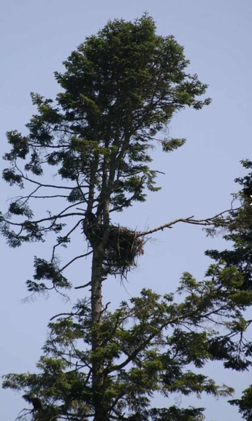

As we approached the waterfront property of the Bloedel Reserve, Dylan spotted a bald eagle flying up to its nest in a tree to the left of the Bloedel home up on the hillside. Since 2005, a pair of resident bald eagles have been courting and laying their eggs each year in February on this tree at Bloedel Reserve. However in July of 2013, during the time I worked in guest services at Bloedel Reserve, the tree limb with the giant nest snapped off, dumping a full-grown but flightless eaglet, apparently unhurt onto the beach below. The adults continued to feed their youngster on the beach until it was able to fly. Apparently, today this pair is still active in the areas near their old nest site. I think of how many of us parents have children who, like the full-grown eaglet hadn't yet spread their wings before the pandemic hit, and are now back home with us in our nests! At least they've got a nest to come home to, unlike the eaglet who was knocked out of its nest by the force of nature! Even so, the adults continued to feed their youngster, like many of us have had to do these past several months. I am confident these children of ours will one day fly away like the full-grown eaglet eventually did!

Continuing our paddle into the wide mouth of Port Madison Bay, I began to feel my homing instinct kick in. Our destination on this day would be my parent's dock at the very end, or head of the Bay, next door to the house where I grew up from 1972 to 1984 in Hidden Cove. My dad's parent's Violet and John Johnsen had a summer cottage on the waterfront in Hidden Cove Bay, where my dad and his siblings in their youth spent summers fishing and swimming. My Grandparents later built their home on this property, and moved to the Island along with my parents who built a home on Hidden Cove in 1972. Manual Road off of highway 305 is named after my great great uncle Charlie Manual, who homesteaded on a plot of land in the bay with his wife Lina back in the late 1800s. A Federal Land grant entitled applicants like Charlie and Lina to free land in Oregon and Washington, providing they settled in these Territories, resided on the land and cultivated it for 4 consecutive years. My dad tells the story of how his great uncle Charlie used his rowboat to row over to Seattle and back in one day, to purchase sheets of wood for the house he was building! Today, the homestead remains with its home intact, old fruit trees in the orchard and the small outbuilding where my great great uncle Charlie pickled herring he caught in the same bay I grew up in swimming, boating and catching dog fish. Nearly 150 years later, our family of five generations appreciate the hard and persistent work of our ancestors, so that we can enjoy the privilege of living on this beautiful island. As Dylan and I paddled into the opening of the Bay, I noticed a motor boat approaching us. As it got closer, I realized it was my dad, Walt who had decided to come out on his boat to greet and accompany us the rest of the way into the bay. Here we are paddling as fast as we can to stay in front of my dad's boat with an old engine that throws off a lot of gassy fumes!
On a 90 degree day in the Northwest when you approach the infamous channel marker, a popular swimming destination for kids hanging out on the Hidden Cove Park District dock, and your son expects you to join him on jumping off the top, it is hard to come up with an excuse not to! In fact, at 54 I can't believe Ive never done this before, having watched my kids throughout the years do this from their grandpas boat... YOLO! It did help that the tide was high, so the drop was only 10 feet or so, and the water was about as warm as it will get all year. The only trick was finding a spot to jump into the water below without hitting a blob of algae sludge!

Two hours later, we timed our landing perfectly on my parents Walt and Bonnie Johnsen's dock, with a dinner from Via Rosa Restaurant that my husband Brendan had just delivered to eat together on my parent's deck, and boy were we hungry!
Section #11 with Katalin Gyorgy and Sue Constan
August 17th, 2020 at 3:30pm
Mom and Dad's dock at Hidden Cove to Fay Bainbridge Park, 2 hours


Note, these two photos are out of order. This first photo is of my two SUP companions finishing our paddle on the inside of Point Monroe Cove. The second photo is us afterwards, back at my parent's dock because we forgot to get a photo of our launch from this spot! This is Kati on the left. I met this amazing woman at Dharma Cafe in the Dayaalu Center where she prepares the yummiest raw and vegan food on Bainbridge Island, and offers yoga classes as well. I recently signed up for her 5 day juice cleanse class, and recommend this to everyone who wants to give their internal and external body a little love and attentions! Never once did I feel depleted or deprived, since the 6 different freshly prepared juices I drank daily were so delicious and nutritious! Look who else I picked up again to join us, Sue who braved the South end paddle around Rich Passage on section #5! Once again, our paths had crossed two weeks prior, as I was finishing up section #8 of my circumnavigation. Sue was launching her SUP that evening for a paddle in Manzanita Bay, and told me she would love to join me on the Port Madison to Fay Bainbridge section! I learned something awesome about Sue on this paddle. She has recently received a Fulbright Fellow award to study an educational learning program in Singapore, and is hoping to get to travel there in January of 2021, congratulations Sue! As we set off the winds had kicked up in the bay, and I jokingly said to Sue that these gusty winds must follow her on the water! By the time we had rounded the bend, the wind ripples on the water had calmed, and there were several other paddle boarders enjoying the afternoon on the water. Everywhere I looked, I could spin stories of spending my summers growing up on this bay waterskiing, swimming, boating and floating. I tell people that this bay was like an inverted neighborhood cul de sac for me growing up. Except, instead of riding bikes or walking to your friends house, I got in a boat and rowed, motored, sailed, swam and even walked to my friends docks in the mud when the tide was out far enough! As a teenager these escapades periodically occurred at night in the summer when the phosphorescence lit up from the wake behind our Boston Whaler, after rowing it out far enough in the bay so my parents wouldn't wake up from the sound of the engine! During these summer months, friends and I dared each other to partake in midnight skinny dipping adventures off our dock, where the phosphorescence glistened off of our bodies and delighted our senses!

This paddle was the first back to back section I had done on my circumnavigation. By this point, I was feeling pretty strong and had no problem doing these 2 hour paddles two days in a row. The tide cycles were a bit more dramatic from the previous day as you can see on the Tide chart, the moon phase is even closer to the new moon, at 2% waning.

As the tide was nearing its highest level that day, we hit some wind as we rounded the point at the mouth of Port Madison Bay, ducking under low lying piers to stay close to the bulkheaded shoreline, as we pointed our SUPs toward Point Monroe/Hedley Spit, or what locals call 'The Sand Spit/Spit'. Approaching the inner cove of Point Monroe, the tide was high enough so that we could paddle into the narrow opening of the shallow water cove. Unfortunately, the outer waters around the point seemed too windy and daunting of a challenge at this point in our paddle to get around to where the boat landing was at Fay Bainbridge. Instead, we paddled into the cove and said hello to some friends of Sue and mine who live on the end of the Spit. Our take out at the far end of the inner cove was just as close to where my truck was parked near the boat launch at Fay Bainbridge Park, so that worked out very well!
Section #12 with Patricia Donbeck and Sam McJunkin
August 24th, 2020 at 6:45am
Fay Bainbridge Park to Patricia Donbeck's home at Rolling Bay Walk

As fate would have it, I ran into my friend Patricia in the produce department of our local grocery store called Town and Country Market, or T&C as us locals refer to it as. As soon as I told her what I was doing this summer on my SUP, she explained that she paddles around on her kayak every morning and does yoga out in front of her home, and would love to join me on one of my sections. I told her I was looking for someone to accompany me on my next section from Fay Bainbridge to Rolling Bay, which just so happened to be right where she lives! Now that I had made my way around the island to the east side, I knew I wanted to experience a sunrise paddle, and now was the time! Here we are as the sun is rising in the east over a very calm Puget Sound morning, before the cargo ships, boat transportation and vessels begin their day. Patricia took a moment before we launched to share her daily sun salutations on the beach with me, raising our arms above us, facing all four directions while thanking each one for this day. Patricia has also helped me and others cultivate our awareness of breath through breath informed movement. She shares in her practice, 'The Breath Cafe' currently on-line through The Dayaalu Center.

On this morning I had chosen to get up for a sunrise paddle, and knew that there may be a chance that the tide was out too far to paddle back out from the inner cove where I had landed after finishing the previous section. Indeed, the water had nearly emptied out of this shallow cove and there was not enough water to paddle through the narrow opening on the other side. Instead, Patricia and I decided to launch on the the Fay Bainbridge side and begin our paddle by paddling to the left around Point Monroe and then double back toward the direction of our landing destination at Patricias on Rolling Bay Walk. I have to admit, had I omitted this section of the my circumnavigation, I would not have been happy with myself, since I had set out to cover all the nooks and crannies of the Bainbridge Shoreline!

This is Patricia's 'hybrid' kayak/paddle board with a seat in the middle that does not get used much from what I understand. Instead, she enjoys paddling on her knees, standing up and even lying down on her belly as she uses her kayak paddle to propel her forward, and sometimes backwards! 30 minutes or so into our paddle, we met up with our friend and Patricia's neighbor Sam, who had paddling in the opposite direction from his home on Rolling Bay Walk to meet us. Sam like me lived on Bainbridge in his youth and feels very comfortable in these NW waters. In fact this summer he has paddled around two thirds of the island on a SUP in just two days, with one more section to go, very impressive! The three of us continued our paddle together down a long section of high bank property on the east side of the Island, called Sunrise Drive, for good reason. The sun had now risen and was glistening off the water.

As Sam shared his practice of staying present by appreciating life in the 'here and now' as things come his way, he pointed down below our boards to a large bed of black sand dollars sticking up from the sand on their sides. At first I wasn't sure what I was looking at, since I had only seen light sand colored sand dollars laying flat or upside down and exposed on sandy beaches. Sam explained that these dark sand dollars are what live ones look like under water (left example, in photo above). The reason I did not recognize them as sand dollars was because we do not see these when the tide goes out. They bury themselves under the sand to protect their shells from drying out. The light colored faded sand dollars that we see on sandy beaches are in fact the dead ones (right example, in photo above). I later realized that this moment with the sand dollars was a demonstration of how to be present and appreciate what is right in front of me, or in this case below my SUP board, because it might not appear to be what it actually is, until you get a closer look! Thank you Sam for this moment in time of learning to be present both on and off my SUP !

Here we are at our landing, where Sam started his paddle, and where he and Patricia live on Rolling Bay Walk. Sam finished his paddle by submerging himself into the water, which he does every time to jump- start his day! I probably wont be doing that, but definitely plan to do another one of these sunrise paddles on the east side of the Island before I complete my circumnavigation by September 6th!
Comments
Post a Comment